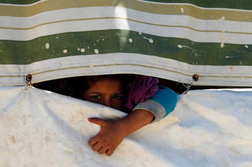
Since 2013, hundreds of thousands of refugees have migrated southward to Jordan to escape the Syrian civil war. The migration has put major stress on Jordan’s water resources, a heavy burden for a country ranked among the most water-poor in the world, even prior to the influx of refugees. However, the refugee crisis also coincided with an unexpected, rapid increase in flow in the Yarmouk River—from Syria to the Al-Wehda reservoir on the Syria-Jordan border. This flow provided a small supplement to Jordan’s agricultural irrigation supply, that although beneficial was modest compared to both the actual freshwater needs of the refugees and the transboundary flow from Syria long anticipated by Jordan.
Given the concurrent refugee migration and river flow increase, we investigated whether a relationship exists among civil conflict, land use, and water consumption in Syria, potentially explaining the observed flow changes in the Yarmouk-Jordan River watershed that is shared by Syria, Jordan, and Israel. In studying this relationship, we found that the rapid increase in the river flow is a consequence of upstream changes stemming from the Syrian civil war. Research findings indicate that the Syrian crisis has resulted in a reduction in irrigated agricultural land in southern Syria, a decline in Syrian water demand for summer irrigation, and a dramatic change in the way the Syrians manage their reservoirs. These changes ultimately resulted in the observed flow increase to downstream Jordan.
How to assess water resources in a war zone
Reliable summer daytime land cultivation maps and urbanization maps (based on night-light images), as well as hydrological data, are essential to investigate the potential relationship between civil conflict, land use, and water consumption, but obtaining on-the-ground data in a war zone is next to impossible. To solve this problem, we turned to remote sensing data. Using spatial and statistical analyses of satellite imagery, we were able to provide evidence of rapid changes in land use, water use, and water management in the southern Syrian Yarmouk-Jordan River watershed.
The migration has put major stress on Jordan’s water resources, a heavy burden for a country ranked among the most water-poor in the world, even prior to the influx of refugees.
In order to test the causal effect of the refugee crisis on land and water resources, we compared changes observed in Syria with corresponding changes observed in nearby regions where irrigation and dam management were unaffected by the refugee crisis: the Jordanian side of the Yarmouk basin to assess changes in irrigated agricultural land use and the Israeli-controlled Golan Heights to evaluate changes in water reservoir management. The causal effect of migration on irrigated land areas and reservoir storage volumes was evaluated statistically by relating pre-migration and post-migration changes in Syria to changes in the control regions over the same periods.
Effect of Syrian migration on land use
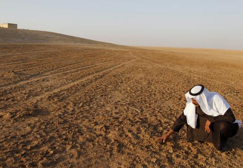
To evaluate the effect of refugee migration on Syrian land use, we generated maps of irrigated crop areas for the Jordanian and Syrian portions of the Yarmouk basin between 2000 and 2015. We found that irrigated areas increased in both countries between 2000 and 2006, followed by an abrupt reduction during the following years, which corresponded to a regional drought. However, in Syria irrigated area declined considerably after 2012, coinciding with the flight of Syrian refugees.
Notably, the post-2012 drop was much greater in Syria than in Jordan, suggesting that conflict and the flight of refugees caused a major reduction in farming and associated reduction in irrigation water use in Syria. Using temporal changes in irrigated area in Jordan as a counterfactual, we found that there was a 47 percent decrease in irrigated land in southern Syria caused by the recent mass migration of refugees that started in 2013.
Effect of the Syrian crisis on reservoir levels
Using remote sensing, we estimated surface reservoir storage changes. We investigated the relationship between refugee migration and Syrian reservoir management by using satellite images of the 11 largest Syrian-controlled surface water reservoirs in the basin for the 2000-15 period. As a control, a similar analysis was conducted for the eight reservoirs operated by Israel in the Golan Heights. The effect of the 2006-08 drought is apparent with a minimum in reservoir storage in both Syria and Israel. Both areas saw increased storage in 2009-12, as the region recovered from the drought, before decreasing again during the low rainfall period of 2013-15. However, the decrease was more substantial in Syria than in the Golan Heights during the time period, which suggests that Syrian reservoir storage was largely affected by changes in the country’s water management practices during the conflict. A comparative difference analysis, revealed a 49 percent decrease in reservoir storage for the 2013-15 refugee migration period compared with the reservoir storage decrease in the Golan Heights, where no detectable change was found during the same period.
Effects on the watershed
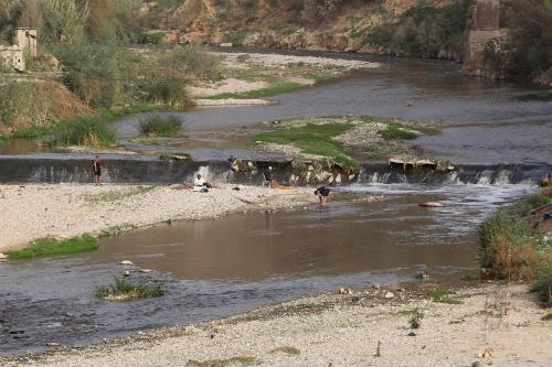
Finally, we evaluated the impacts of refugee migration along with associated land-use and reservoir storage changes on the hydrological response of the watershed. Coinciding with the refugee crisis of 2013-15, measured inflows into the Al-Wehda reservoir on the Jordan border reveal a three-fold increase in annual flow compared to the 2006-12 period. The imagery showed that Syrian dams retained considerably less wet-season runoff during the refugee migration period compared with prior years. The decreased retention of wet-season flows during the refugee migration period accounts for almost half of the flow increase reaching Jordan.
Armed conflict resulted in significant changes to land use and water management in Syria, and ultimately, in an unanticipated increase in transboundary flow to downstream Jordan.
The refugee crisis also caused a significant decrease in irrigation demand, which likely increased the portion of reservoir releases making it back from irrigation canals to the stream during the summer. We found that about half of the stream flow increase between 2006-12 and 2013-15 is attributable to the rapid migration of Syrian refugees and subsequent abandonment of irrigated agriculture in southern Syria.
Conflict and the implications for water users
Our analysis suggests that the Syrian conflict and subsequent refugee migration caused downstream flow to increase primarily by the reduction in irrigation demand and changes in reservoir management practices. The abnormal recent decrease in Syrian water retention detected on satellite imagery is consistent with reports from the field, which point to the underuse or decommissioning of dams due to targeted military operations and poor operational management.
Related Books


Armed conflict resulted in significant changes to land use and water management in Syria, and ultimately, in an unanticipated increase in transboundary flow to downstream Jordan. Importantly, the unintended, near-term impact on Jordan represents a very modest irrigation water benefit that does not materially offset the immediate freshwater needs for hundreds of thousands of Syrian refugees received by Jordan. In fact, even with the additional flow Jordan gets far less transboundary water than it anticipated receiving under a series of bilateral water sharing agreements with Syria. This study reveals how conflict can significantly alter the basin-scale water balance with water supply implications for water users in the basin. The work additionally shows the benefit of using counterfactual comparisons combined with satellite remote sensing data to evaluate hydrologic and land-use dynamics in a war zone.
Acknowledgments: This work was supported by the National Science Foundation (NSF) under Grant GEO/OAD-1342869 (to Stanford University). Any opinions, findings, and conclusions or recommendations expressed in this material are those of the authors and do not necessarily reflect the views of the NSF.
Related Content


Commentary
How the Syrian refugee crisis affected land use and shared transboundary freshwater resources
February 13, 2017